Lindeman, O.
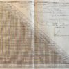
Cartography World 1775 | Engraving and etching of the world: Zeekaart (map of the sea’s) tonende afwijkingen van het kompas (deviations compass), made in 1775, 1 p.
Fullt title: Nieuwe en Nette Zeekaart van de Geheele Waareld toonende de Afwijkingen van het kompas gelijk zij bevonden zijn anno 1700 met eene aanwijzing der Algmene en op de kusten waaiende passat winden en van de Moulons of veranderende passaat winden. Gemaakt onder ‘t opzigt van Kapitein Edmund Halley. Map made by O. Lindeman in Almelo fecit 1775.
Halley did research on the conditions of terestrial magnetism. The results were published in General chart of the variation of the Compass. This was the first chart to be published and the first on which isogonic, or Halleyan, lines appeared. The use of such lines inspired later ideas such as those of isotherms by Alexander von Humboldt in his maps.
World map after data of Edmond Halley ca. 1700, published by O. Lindeman in Almelo. With particular attention to the prevailing winds. With a demi-hemisphere insert map of the North Pole.
[NL] Antieke zeekaart met de afwijkingen van het kompas door magnetisme. Gemaakt door de beroemde astronomist en natuurkundige Edmund Halley. Edmond of Edmund Halley (1656-1742) was een Engelse astronomist, wiskundige en natuurkundige.
SKU: PR121408
Original engraving and etching on laid paper. With 4 visible verticle folds and small creaes on the edges, a bigger crease on the bottom right. Total size: 240 x 500 mm.
€ 302,50(€ 250,00


![[Publication water management 1880] Nota der Commissie van hoofdingenieurs betr. den brief van het Amsterdamsche Rijnvaart-Comite aan den minister, d.d. 26-11-1880. 's-Gravenhage, 1881, 5+3+4+8 pag., gebonden.](https://arinevandersteur.nl/wp-content/uploads/WhatsApp-Image-2022-03-15-at-10.09.45-AM-356x356.jpeg)
![[Publication water management 1880] Nota der Commissie van hoofdingenieurs betr. den brief van het Amsterdamsche Rijnvaart-Comite aan den minister, d.d. 26-11-1880. 's-Gravenhage, 1881, 5+3+4+8 pag., gebonden.](https://arinevandersteur.nl/wp-content/uploads/WhatsApp-Image-2022-03-15-at-10.09.46-AM-6-356x356.jpeg)
![[Antique print, etching and engraving] Het doorbreken van de St. Anthonis Dijk buiten Amsterdam op den 5e maart 1651, published 1728.](https://arinevandersteur.nl/wp-content/uploads/WhatsApp-Image-2022-08-25-at-11.34.03-AM-356x356.jpeg)
![[Antique print, etching] Dijkdoorbraak bij Coevorden [Dike breach at Coevorden, 1st October 1673], published 1675.](https://arinevandersteur.nl/wp-content/uploads/59994_2_2-356x277.jpg)
![[Antique print, etching] Dijkdoorbraak bij Coevorden [Dike breach at Coevorden, 1st October 1673], published 1675.](https://arinevandersteur.nl/wp-content/uploads/59994_1_2-356x273.jpg)
![[Manuscript 1741] Eigenhandige verklaring d.d. ‘s-Gravenhage 11-9-1741 van Anthonie Slicher, raed ords in het Hof van Holland over een erboven in kleur getekend wapen Beyeren van Schagen. Manuscript, 1 p, folio, met de handtekening van Slicher.](https://arinevandersteur.nl/wp-content/uploads/WhatsApp-Image-2021-03-23-at-11.28.23-1-356x356.jpeg)