![[Cartography/cartografie] Plan de Batavia [from: "L' Atlas curieux, ou Le monde réprésenté dans des cartes générales et particulieéres du ciel et de la terre"]/Kaart van Batavia (nu Jakarta).](https://arinevandersteur.nl/wp-content/uploads/65915_1-scaled-1.jpg "[Cartography/cartografie] Plan de Batavia [from: \"L' Atlas curieux, ou Le monde réprésenté dans des cartes générales et particulieéres du ciel et de la terre\"]/Kaart van Batavia (nu Jakarta)")
de Fer, Nicolas (1646-1720)
[Cartography/cartografie] Plan de Batavia [from: “L’ Atlas curieux, ou Le monde réprésenté dans des cartes générales et particulieéres du ciel et de la terre”]/Kaart van Batavia (nu Jakarta).
SKU: 65915
Etching on paper, hand-colored, with margins and mounted in passepartout; plate mark: 226 x 288 mm, total: 295 x 383; staining and smudges on the top and right margins; wide watermark and countermark with Amsterdam coat of arms.
€ 145,20 (€ 120,00 ex. btw)
Out of stock
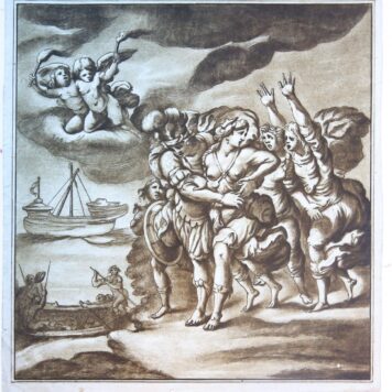
![[Allegorical etching and engraving/allegorische ets en gravure] Allegory of the alliance between the Netherlands and France/Allegorie van het verbond tussen Frankrijk en Nederland.](https://arinevandersteur.nl/wp-content/uploads/65914_3-scaled-1-100x100.jpg)
![[Handcolored engraving/Handgkleurde gravure] Flandria maximus et pulcherrimus Europae Comitat.../Vlaanderen met Brugge en Gent.](https://arinevandersteur.nl/wp-content/uploads/65898_1-scaled-1.jpg)